
(Optimizado para dispositivos de pantalla pequeña)
Liberty Bridge (aka Freedom Bridge, "Szabadság híd") - Budapest, Hungría
Cuando se hace clic:
¡Haga clic en las imágenes!
-

The Liberty Bridge of Budapest ("Szabadság híd") over the Danube River and in front of the Gellért Hill ("Gellért-hegy")
Fecha de la fotografía: 20132013
Creado por: Robert Németh
Modelo de la cámara: Konica Minolta Dimage A200
Budapest, Hungría
-

The Pest-side tower (pylon) of the Liberty Bridge ("Szabadság híd") in front of the Gellért Hill
Fecha de la fotografía: 20132013
Creado por: Robert Németh
Modelo de la cámara: Konica Minolta Dimage A200
Budapest, Hungría
-

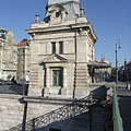
Former customs house at the Pest side of the Liberty Bridge ("Szabadság híd")
Fecha de la fotografía: 20132013
Creado por: Robert Németh
Modelo de la cámara: Konica Minolta Dimage A200
Budapest, Hungría
-

The sight of the Liberty Bridge ("Szabadság híd") and the Buda Castle Quarter from the promenade on the Danube bank in Pest
Fecha de la fotografía: 20132013
Creado por: Robert Németh
Modelo de la cámara: Konica Minolta Dimage A200
Budapest, Hungría
-

The view of the Liberty Bridge from the Pest bank of the Danube
Fecha de la fotografía: 20062006
Creado por: Robert Németh
Modelo de la cámara: Konica Minolta Dimage A200
Budapest, Hungría
-

The Liberty Bridge ("Szabadság híd") over the Danube River, as seen from the Gellért Hill
Fecha de la fotografía: 20112011
Creado por: Robert Németh
Modelo de la cámara: Konica Minolta Dimage A200
Budapest, Hungría
-

One of the ornate four-way lamp posts of the Liberty Bridge
In the background it is the Central Market Hall.
Fecha de la fotografía: 20132013
Creado por: Robert Németh
Modelo de la cámara: Konica Minolta Dimage A200
Budapest, Hungría
-

Ornate four-way lamp post on the Liberty Bridge ("Szabadság híd")
Fecha de la fotografía: 20132013
Creado por: Robert Németh
Modelo de la cámara: Konica Minolta Dimage A200
Budapest, Hungría
-

Some lamps of the Liberty Bridge
Fecha de la fotografía: 20132013
Creado por: Robert Németh
Modelo de la cámara: Konica Minolta Dimage A200
Budapest, Hungría
-

The other former customs house of the Liberty Bridge ("Szabadság híd"), in front of the main building of the Corvinus University
Fecha de la fotografía: 20132013
Creado por: Robert Németh
Modelo de la cámara: Konica Minolta Dimage A200
Budapest, Hungría
-
The foot of the Gellért Hill viewed from the Liberty Bridge ("Szabadság híd")
Fecha de la fotografía: 20132013
Creado por: Robert Németh
Modelo de la cámara: Konica Minolta Dimage A200
Budapest, Hungría
The foot of the Gellért Hill viewed from the Liberty Bridge ("Szabadság híd") - Budapest, Hungría -
The end of the Liberty Bridge ("Szabadság híd") and the lower embankment on the Pest side of the river
Fecha de la fotografía: 20132013
Creado por: Robert Németh
Modelo de la cámara: Konica Minolta Dimage A200
Budapest, Hungría
The end of the Liberty Bridge ("Szabadság híd") and the lower embankment on the Pest side of the river - Budapest, Hungría -
The Pest-side end of the Liberty Bridge ("Szabadság híd")
Fecha de la fotografía: 20132013
Creado por: Robert Németh
Modelo de la cámara: Konica Minolta Dimage A200
Budapest, Hungría
The Pest-side end of the Liberty Bridge ("Szabadság híd") - Budapest, Hungría -
The view of the Liberty Bridge ("Szabadság híd") towards Buda
Fecha de la fotografía: 20132013
Creado por: Robert Németh
Modelo de la cámara: Konica Minolta Dimage A200
Budapest, Hungría
The view of the Liberty Bridge ("Szabadság híd") towards Buda - Budapest, Hungría -
The connection of the Liberty Bridge ("Szabadság híd") on the Pest riverside
Fecha de la fotografía: 20132013
Creado por: Robert Németh
Modelo de la cámara: Konica Minolta Dimage A200
Budapest, Hungría
The connection of the Liberty Bridge ("Szabadság híd") on the Pest riverside - Budapest, Hungría -
The Pest-side end of the Liberty Bridge ("Szabadság híd"), and the main building of the Corvinus University in the background
Fecha de la fotografía: 20132013
Creado por: Robert Németh
Modelo de la cámara: Konica Minolta Dimage A200
Budapest, Hungría
The Pest-side end of the Liberty Bridge ("Szabadság híd"), and the main building of the Corvinus University in the background - Budapest, Hungría -
Passers-by on the Liberty Bridge ("Szabadság híd")
Fecha de la fotografía: 20132013
Creado por: Robert Németh
Modelo de la cámara: Konica Minolta Dimage A200
Budapest, Hungría
Passers-by on the Liberty Bridge ("Szabadság híd") - Budapest, Hungría -
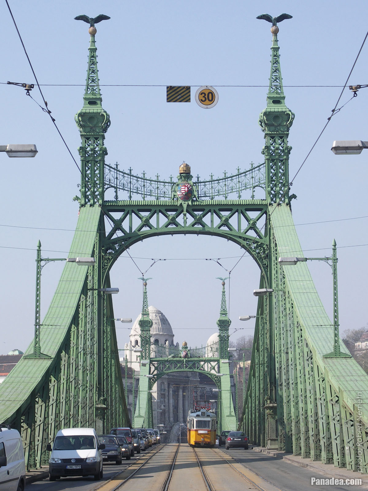
A tram on the Liberty Bridge
Fecha de la fotografía: 20132013
Creado por: Robert Németh
Modelo de la cámara: Konica Minolta Dimage A200
Budapest, Hungría
A tram on the Liberty Bridge - Budapest, Hungría -
The sight from the Libery Bridge northwards: the Danube River, the Gellért Hill, the Elisabeth Bridge and the Buda Castle
Fecha de la fotografía: 20132013
Creado por: Robert Németh
Modelo de la cámara: Konica Minolta Dimage A200
Budapest, Hungría
The sight from the Libery Bridge northwards: the Danube River, the Gellért Hill, the Elisabeth Bridge and the Buda Castle - Budapest, Hungría -
Old customs house, today museum with exhibition that presents the Danube bridges of Budapest
Fecha de la fotografía: 20132013
Creado por: Robert Németh
Modelo de la cámara: Konica Minolta Dimage A200
Budapest, Hungría
Old customs house, today museum with exhibition that presents the Danube bridges of Budapest - Budapest, Hungría -
Simplified coat of arms of Hungary on the Liberty Bridge ("Szabadság híd")
Fecha de la fotografía: 20132013
Creado por: Robert Németh
Modelo de la cámara: Konica Minolta Dimage A200
Budapest, Hungría
Simplified coat of arms of Hungary on the Liberty Bridge ("Szabadság híd") - Budapest, Hungría -
The Liberty Bridge ("Szabadság híd") to the direction of Buda
Fecha de la fotografía: 20132013
Creado por: Robert Németh
Modelo de la cámara: Konica Minolta Dimage A200
Budapest, Hungría
The Liberty Bridge ("Szabadság híd") to the direction of Buda - Budapest, Hungría -
Detail of the Liberty Bridge
Fecha de la fotografía: 20132013
Creado por: Robert Németh
Modelo de la cámara: Konica Minolta Dimage A200
Budapest, Hungría
Detail of the Liberty Bridge - Budapest, Hungría -
The green-painted Liberty Bridge ("Szabadság híd")
Fecha de la fotografía: 20132013
Creado por: Robert Németh
Modelo de la cámara: Konica Minolta Dimage A200
Budapest, Hungría
The green-painted Liberty Bridge ("Szabadság híd") - Budapest, Hungría -
The Pest-side pylon of the Libery Bridge ("Szabadság híd")
Fecha de la fotografía: 20132013
Creado por: Robert Németh
Modelo de la cámara: Konica Minolta Dimage A200
Budapest, Hungría
The Pest-side pylon of the Libery Bridge ("Szabadság híd") - Budapest, Hungría -
The surroundings of the Liberty Bridge on the Pest side of the river (embankment, Danube, bridge, etc.)
Fecha de la fotografía: 20132013
Creado por: Robert Németh
Modelo de la cámara: Konica Minolta Dimage A200
Budapest, Hungría
The surroundings of the Liberty Bridge on the Pest side of the river (embankment, Danube, bridge, etc.) - Budapest, Hungría -
A tower (pylon) of the Liberty Bridge ("Szabadság híd") with the bronze sculpture of a falcon-like turul bird, as well as the Libery Statue on the Gellért Hill (in the distance)
Fecha de la fotografía: 20132013
Creado por: Robert Németh
Modelo de la cámara: Konica Minolta Dimage A200
Budapest, Hungría
A tower (pylon) of the Liberty Bridge ("Szabadság híd") with the bronze sculpture of a falcon-like turul bird, as well as the Libery Statue on the Gellért Hill (in the distance) - Budapest, Hungría -
One of the towers (pylons) of the Liberty Bridge ("Szabadság híd") with two turul bird sculptures on its top, and the Liberty Statue on the Gellért Hill in the background
Fecha de la fotografía: 20132013
Creado por: Robert Németh
Modelo de la cámara: Konica Minolta Dimage A200
Budapest, Hungría
One of the towers (pylons) of the Liberty Bridge ("Szabadság híd") with two turul bird sculptures on its top, and the Liberty Statue on the Gellért Hill in the background - Budapest, Hungría -
The Pest-side lower embankment, as well as the Liberty Bridge ("Szabadság híd") over River Danube
Fecha de la fotografía: 20132013
Creado por: Robert Németh
Modelo de la cámara: Konica Minolta Dimage A200
Budapest, Hungría
The Pest-side lower embankment, as well as the Liberty Bridge ("Szabadság híd") over River Danube - Budapest, Hungría -
The Liberty Bridge ("Szabadság híd") over the river
Fecha de la fotografía: 20132013
Creado por: Robert Németh
Modelo de la cámara: Konica Minolta Dimage A200
Budapest, Hungría
The Liberty Bridge ("Szabadság híd") over the river - Budapest, Hungría -
Liberty Bridge ("Szabadság híd", formerly "Ferencz József híd", "Fővám téri híd") over River Danube
Fecha de la fotografía: 20062006
Creado por: Robert Németh
Modelo de la cámara: Konica Minolta Dimage A200
Budapest, Hungría
Liberty Bridge ("Szabadság híd", formerly "Ferencz József híd", "Fővám téri híd") over River Danube - Budapest, Hungría -
Liberty Bridge (in Hungarian "Szabadság híd"), as well as the Gellért Hotel and Gellért Bath in the distance
Fecha de la fotografía: 20062006
Creado por: Robert Németh
Modelo de la cámara: Konica Minolta Dimage A200
Budapest, Hungría
Liberty Bridge (in Hungarian "Szabadság híd"), as well as the Gellért Hotel and Gellért Bath in the distance - Budapest, Hungría -
Liberty Bridge ("Szabadság híd") over the flooded Danube, viewed from Gellért Hill
Fecha de la fotografía: 20062006
Creado por: Robert Németh
Modelo de la cámara: Konica Minolta Dimage A200
Budapest, Hungría
Liberty Bridge ("Szabadság híd") over the flooded Danube, viewed from Gellért Hill - Budapest, Hungría -
The Liberty Bridge ("Szabadság híd") and the flooding River Danube from Gellért Hill
Fecha de la fotografía: 20062006
Creado por: Robert Németh
Modelo de la cámara: Konica Minolta Dimage A200
Budapest, Hungría
The Liberty Bridge ("Szabadság híd") and the flooding River Danube from Gellért Hill - Budapest, Hungría -
Coat of arms of Hungary and sculptures of turul birds on the pylon (tower) of the Liberty Bridge or "Szabadság híd"
Fecha de la fotografía: 20062006
Creado por: Robert Németh
Modelo de la cámara: Konica Minolta Dimage A200
Budapest, Hungría
Coat of arms of Hungary and sculptures of turul birds on the pylon (tower) of the Liberty Bridge or "Szabadság híd" - Budapest, Hungría -
The view of the Buda-side embankment and the Hotel Gellért from the Liberty Bridge in the evening
Fecha de la fotografía: 20042004
Creado por: Robert Németh
Modelo de la cámara: Canon PowerShot A85
Budapest, Hungría
The view of the Buda-side embankment and the Hotel Gellért from the Liberty Bridge in the evening - Budapest, Hungría


¡Haga clic en las imágenes!
Características, propiedades
Posición:
Coordenadas GPS: Latitud 47°29'8", Longitud 19°3'17" (N47 29.13 - E19 3.28)
Información, historias cortas, datos interesantes
 Liberty Bridge ("Szabadság híd", formerly "Ferencz József híd", "Fővám téri híd") over River Danube
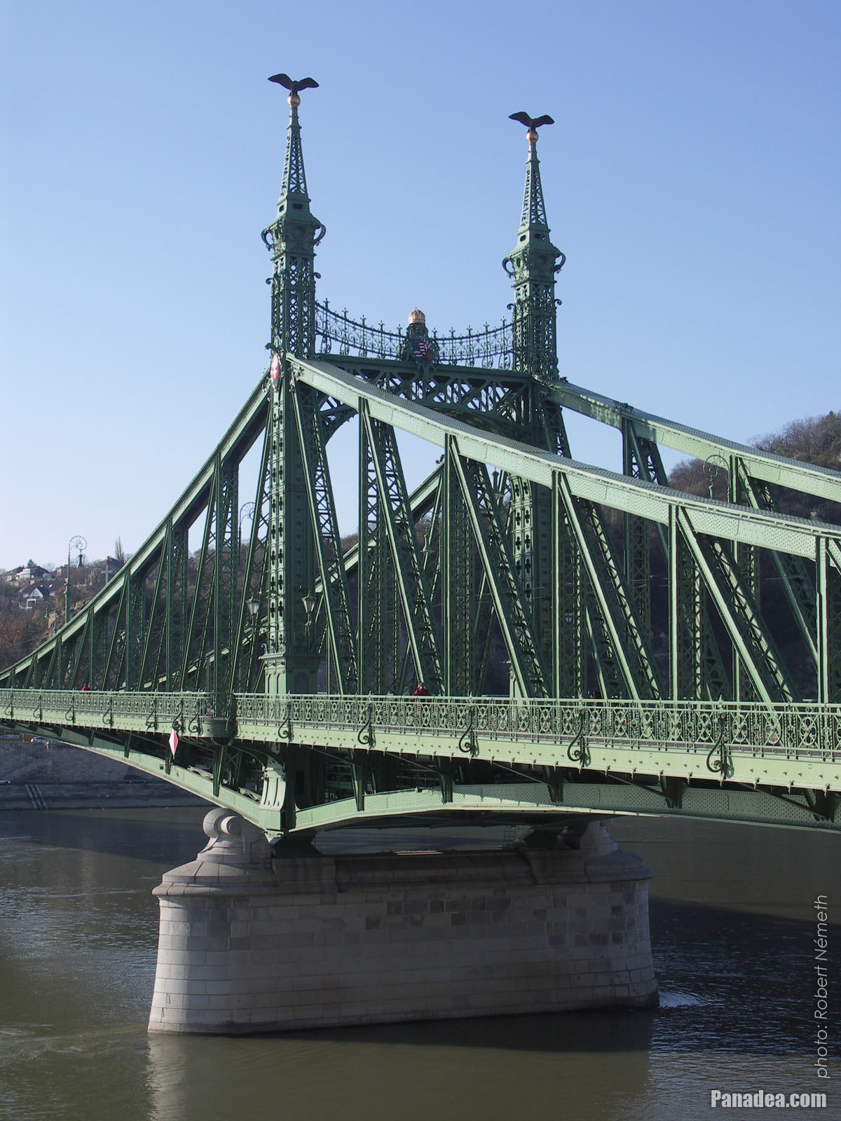
The Liberty Bridge or Freedom Bridge (also known as Freedom Bridge, in Hungarian "Szabadság híd") or as it was called initially the Franz Joseph Bridge ("Ferencz József híd") was designed by János Feketeházy, it was opened in the year of the Hungarian Millenium in 1896. This was the third permanent road crossing over the Danube in Budapest. Even then the bridge already had tram tracks, as well as electric and gas lighting.
The first tram went throught the Liberty Bridge ("Szabadság híd") in 1898. At that time the tham tracks were on the sides of the bridge deck, and the tram used a conduit current collection system (the electric wires were on the ground) to get the power. The tram line was converted to overhead wire system in 1923, and from 1928 also the bus traffic was started on the bridge. Then in 1938 the rails were moved to the middle of the road, as it can be seen today.
Another characteristics of the Szabadság Bridge or Liberty Bridge are the statues of turul birds with outstretched wings on the top of the pylon gates that were designed by Virgil Nagy, as well as the historical Hungarian coat of arms on the gateways (all of them were made in 1896).
 Liberty Bridge ("Szabadság híd") over the flooded Danube, viewed from Gellért Hill
The Liberty Bridge (or Freedom Bridge, in Hungarian "Szabadság híd") is the shortest among the Danube bridges of Budapest. Before the World War II it was called Franz Joseph Bridge or Fővám Square Bridge ("Ferenc József híd" or "Fővám téri híd").
At the end of the World War II the bridge was blown up by the retreating German troops, like every other Danube bridge of Budapest. But the piers (more precisely the pylons) were remained intact and also the reparation of the middle section could be done relatively quickly. The reconstruction was done soon by the plans of Pál Sávoly architect, in 1946 it was already opened for service and then got its new name: "Szabadság híd" (in English "Liberty Bridge" or "Freedom Bridge").
Budapest - Más galerías de fotos:
Es posible que también le interesa (Páginas relacionadas):
Destinos en la guía de viaje:
Budapest (8 468 fotos + 21 fotos panorámicas)
Buda Hills (Budai-hegység) (8 632 fotos + 21 fotos panorámicas)
Pest megye (county) (15 122 fotos + 50 fotos panorámicas)
Budapest y sus alrededores (15 989 fotos + 52 fotos panorámicas)
Hungría (27 287 fotos + 163 fotos panorámicas)
y además:
(dentro de aquí: Buda Hills)
Budakeszi (88 fotos)
Pilisszentiván (76 fotos)
Cada fotografía panorámica en:
Budapest (21 fotos)
Pest megye (county) (50 fotos)
Budapest y sus alrededores (52 fotos)
Hungría (163 fotos)
Europa (165 fotos)
Todas las fotografías normales en:
Budapest (8 468 fotos / 122 galerías)
Buda Hills (Budai-hegység) (8 632 fotos / 124 galerías)
Pest megye (county) (15 122 fotos / 221 galerías)
Budapest y sus alrededores (15 989 fotos / 234 galerías)
Hungría (27 287 fotos / 462 galerías)
Europa (30 494 fotos / 523 galerías)
https://www.panadea.com/es/guidebook/budapest/photos/gal-014

Añadir a Favoritos Añadir a Marcadores
¡Comparte con tus amigos!
etc.


Nuestra guía turística contiene :
Numerosas fotografías e imágenes panorámicas, con una gran cantidad de información y datos interesantes.
- 214 destinos de viaje
- 165 fotos panorámicas
- 30 494 otras fotos
Gran colección de fotos seleccionadas: excelente calidad, alta resolución y colores naturales
Sobre nosotros - Aviso jurídico & Exención de responsabilidad -
Todos los derechos reservados
- ©2010-2022
Neuronit Creative Studio - Mogyoród / Budapest / Hungría