
(Optimalizované pre zariadenia s malou obrazovkou)
Downtown, main square and pedestrian mall - Hódmezővásárhely, Maďarsko
Po kliknutí:
Kliknutím na obrázky!
-

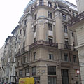
Beautifully renovated two-storey residental buildings on the street that is transformed to a pedestrian only zone
Dátum fotenie: 4.7.20142014
Vytvoril: Robert Németh
Model fotoaparátu: Konica Minolta Dimage A200
Hódmezővásárhely, Maďarsko
-

The Art Nouveau (secession) style Bank Palace or "Grand Savings Bank", viewed from the park
Dátum fotenie: 4.7.20142014
Vytvoril: Robert Németh
Model fotoaparátu: Konica Minolta Dimage A200
Hódmezővásárhely, Maďarsko
-

The tower of the City Hall, as well as the World War I memorial with the hussar horseman statue in front of it
Dátum fotenie: 4.7.20142014
Vytvoril: Robert Németh
Model fotoaparátu: Konica Minolta Dimage A200
Hódmezővásárhely, Maďarsko
-

The Art Nouveau style former Gentlemen's Casino or Aristocrats' Casino ("Úri Kaszinó")
From the 1960s until 1989 it was a Youth Center (in Hungarian "Ifjúsági Ház").
Dátum fotenie: 4.7.20142014
Vytvoril: Robert Németh
Model fotoaparátu: Konica Minolta Dimage A200
Hódmezővásárhely, Maďarsko
-

The yellow-painted former Fekete Sas Hotel (Hotel Black Eagle) on the main square
Dátum fotenie: 4.7.20142014
Vytvoril: Robert Németh
Model fotoaparátu: Konica Minolta Dimage A200
Hódmezővásárhely, Maďarsko
-

Tornyai János Museum and Community Cultural Center, the white Klein House and a small park in front of it
Dátum fotenie: 4.7.20142014
Vytvoril: Robert Németh
Model fotoaparátu: Konica Minolta Dimage A200
Hódmezővásárhely, Maďarsko
-

The so-called Klein House with the János Tornyai Museum and Community Cultural Center within it
This building became the part of the institution in 1950, during the deprivatisations.
Dátum fotenie: 4.7.20142014
Vytvoril: Robert Németh
Model fotoaparátu: Konica Minolta Dimage A200
Hódmezővásárhely, Maďarsko
-

"Viewpoint" or "Aspect", modern metal sculpture in memory of the world famous photographer Lucien Hervé (Hódmezővásárhely, 1910 - Paris, 2007)
Created of stainless chromium steel by Nándor V. Nagy in 2012.
Dátum fotenie: 4.7.20142014
Vytvoril: Robert Németh
Model fotoaparátu: Konica Minolta Dimage A200
Hódmezővásárhely, Maďarsko
-

Fountains and ornamental bushes in the new pedestrian mall
Dátum fotenie: 4.7.20142014
Vytvoril: Robert Németh
Model fotoaparátu: Konica Minolta Dimage A200
Hódmezővásárhely, Maďarsko
-

Small fountain embedded into the pavement
Dátum fotenie: 4.7.20142014
Vytvoril: Robert Németh
Model fotoaparátu: Konica Minolta Dimage A200
Hódmezővásárhely, Maďarsko
-
The landscaped part of the new pedestrian zone at the János Tornyai Museum
Dátum fotenie: 4.7.20142014
Vytvoril: Robert Németh
Model fotoaparátu: Konica Minolta Dimage A200
Hódmezővásárhely, Maďarsko
The landscaped part of the new pedestrian zone at the János Tornyai Museum - Hódmezővásárhely, Maďarsko -
The facade of the Tornyai János Museum that was founded around 1904-1905
This building was built in 1899 for Dr. József Imre hospital director and chief physician, architect: Gyula Sándy.
Dátum fotenie: 4.7.20142014
Vytvoril: Robert Németh
Model fotoaparátu: Konica Minolta Dimage A200
Hódmezővásárhely, Maďarsko
The facade of the Tornyai János Museum that was founded around 1904-1905 - Hódmezővásárhely, Maďarsko -
Tornyai János Museum and Community Cultural Center
Dátum fotenie: 4.7.20142014
Vytvoril: Robert Németh
Model fotoaparátu: Konica Minolta Dimage A200
Hódmezővásárhely, Maďarsko
Tornyai János Museum and Community Cultural Center - Hódmezővásárhely, Maďarsko -
Hungarian Art Nouveau flower ornament
Dátum fotenie: 4.7.20142014
Vytvoril: Robert Németh
Model fotoaparátu: Konica Minolta Dimage A200
Hódmezővásárhely, Maďarsko
Hungarian Art Nouveau flower ornament - Hódmezővásárhely, Maďarsko -
The entrance of the Tornyai János Museum (or Janos Tornyai Museum)
Dátum fotenie: 4.7.20142014
Vytvoril: Robert Németh
Model fotoaparátu: Konica Minolta Dimage A200
Hódmezővásárhely, Maďarsko
The entrance of the Tornyai János Museum (or Janos Tornyai Museum) - Hódmezővásárhely, Maďarsko -
Bust sculpture of the Hungarian painter János Tornyai, master of the Alföld School art movement, standing in the niche of the museum
Originally this statue was placed at the Serbian Orthodox church.
Dátum fotenie: 4.7.20142014
Vytvoril: Robert Németh
Model fotoaparátu: Konica Minolta Dimage A200
Hódmezővásárhely, Maďarsko
Bust sculpture of the Hungarian painter János Tornyai, master of the Alföld School art movement, standing in the niche of the museum - Hódmezővásárhely, Maďarsko -
Bust statue of János Tornyai (1869-1936) Hungarian painter in the wall niche of the museum that is named after him
Created by Tamás Gyenes in 1956, renovated and moved to here in 2012.
Dátum fotenie: 4.7.20142014
Vytvoril: Robert Németh
Model fotoaparátu: Konica Minolta Dimage A200
Hódmezővásárhely, Maďarsko
Bust statue of János Tornyai (1869-1936) Hungarian painter in the wall niche of the museum that is named after him - Hódmezővásárhely, Maďarsko -
The pedestrian street and the new modern entrance of the Tornyai János Museum
Dátum fotenie: 4.7.20142014
Vytvoril: Robert Németh
Model fotoaparátu: Konica Minolta Dimage A200
Hódmezővásárhely, Maďarsko
The pedestrian street and the new modern entrance of the Tornyai János Museum - Hódmezővásárhely, Maďarsko -
The "Viewpoint" modern metal sculpture in front of the Tornyai János Museum, representing a symbolic camera lens
Created by Nándor V. Nagy in 2012
Dátum fotenie: 4.7.20142014
Vytvoril: Robert Németh
Model fotoaparátu: Konica Minolta Dimage A200
Hódmezővásárhely, Maďarsko
The "Viewpoint" modern metal sculpture in front of the Tornyai János Museum, representing a symbolic camera lens - Hódmezővásárhely, Maďarsko -
Pedestrian mall (pedestrian only street)
Dátum fotenie: 4.7.20142014
Vytvoril: Robert Németh
Model fotoaparátu: Konica Minolta Dimage A200
Hódmezővásárhely, Maďarsko
Pedestrian mall (pedestrian only street) - Hódmezővásárhely, Maďarsko -
Small park with recently planted trees beside the Orthodox church
Dátum fotenie: 4.7.20142014
Vytvoril: Robert Németh
Model fotoaparátu: Konica Minolta Dimage A200
Hódmezővásárhely, Maďarsko
Small park with recently planted trees beside the Orthodox church - Hódmezővásárhely, Maďarsko -
The small park near the Serbian Orthodox church
Dátum fotenie: 4.7.20142014
Vytvoril: Robert Németh
Model fotoaparátu: Konica Minolta Dimage A200
Hódmezővásárhely, Maďarsko
The small park near the Serbian Orthodox church - Hódmezővásárhely, Maďarsko -
The park and the entrance of the Tornyai János Museum
Dátum fotenie: 4.7.20142014
Vytvoril: Robert Németh
Model fotoaparátu: Konica Minolta Dimage A200
Hódmezővásárhely, Maďarsko
The park and the entrance of the Tornyai János Museum - Hódmezővásárhely, Maďarsko -
The now orange colored Serbian Orthodox church
The renovation of the church was completed in 2014. Just to mention, formerly the building was dark red and white colored.
Dátum fotenie: 4.7.20142014
Vytvoril: Robert Németh
Model fotoaparátu: Konica Minolta Dimage A200
Hódmezővásárhely, Maďarsko
The now orange colored Serbian Orthodox church - Hódmezővásárhely, Maďarsko -
The "Barge" or "Ark" modern style abstract sculpture in the small park at the Orthodox church
Dátum fotenie: 4.7.20142014
Vytvoril: Robert Németh
Model fotoaparátu: Konica Minolta Dimage A200
Hódmezővásárhely, Maďarsko
The "Barge" or "Ark" modern style abstract sculpture in the small park at the Orthodox church - Hódmezővásárhely, Maďarsko -
"Ark" or "Barge", modern bronze sculpture on a limestone column
Created by Ildikó Albert in 2012
Dátum fotenie: 4.7.20142014
Vytvoril: Robert Németh
Model fotoaparátu: Konica Minolta Dimage A200
Hódmezővásárhely, Maďarsko
"Ark" or "Barge", modern bronze sculpture on a limestone column - Hódmezővásárhely, Maďarsko -
The Serbian Orthodox church of Hódmezővásárhely
Due to the the "Patent of Toleration" edict of Emperor Joseph II of Austria it couldn't built on the street front, that is why the church stands to the street with its back.
Dátum fotenie: 4.7.20142014
Vytvoril: Robert Németh
Model fotoaparátu: Konica Minolta Dimage A200
Hódmezővásárhely, Maďarsko
The Serbian Orthodox church of Hódmezővásárhely - Hódmezővásárhely, Maďarsko -
The Serbian Orthodox church in Hódmezővásárhely
It was built in 1783 by Greek settlers, who ran away from the Greek-Turkish wars. The bell tower was constructed some times later, in 1806.
Dátum fotenie: 4.7.20142014
Vytvoril: Robert Németh
Model fotoaparátu: Konica Minolta Dimage A200
Hódmezővásárhely, Maďarsko
The Serbian Orthodox church in Hódmezővásárhely - Hódmezővásárhely, Maďarsko -
Wonderful biedermeier style iconostasis (wall of icons) in the Serbian Orthodox church
The iconostasis was carved in around the 1820s, as well as the icon pictures on it were painted in the 18th-19th centuries.
Dátum fotenie: 4.7.20142014
Vytvoril: Robert Németh
Model fotoaparátu: Konica Minolta Dimage A200
Hódmezővásárhely, Maďarsko
Wonderful biedermeier style iconostasis (wall of icons) in the Serbian Orthodox church - Hódmezővásárhely, Maďarsko -
Carved wooden chandelier in the Serbian Orthodox church
Dátum fotenie: 4.7.20142014
Vytvoril: Robert Németh
Model fotoaparátu: Konica Minolta Dimage A200
Hódmezővásárhely, Maďarsko
Carved wooden chandelier in the Serbian Orthodox church - Hódmezővásárhely, Maďarsko -
The baroque style iconostasis of the Serbian Orthodox church
Dátum fotenie: 4.7.20142014
Vytvoril: Robert Németh
Model fotoaparátu: Konica Minolta Dimage A200
Hódmezővásárhely, Maďarsko
The baroque style iconostasis of the Serbian Orthodox church - Hódmezővásárhely, Maďarsko -
The so-called Marian throne or Virgin Mary's throne in the Orthodox church
Dátum fotenie: 4.7.20142014
Vytvoril: Robert Németh
Model fotoaparátu: Konica Minolta Dimage A200
Hódmezővásárhely, Maďarsko
The so-called Marian throne or Virgin Mary's throne in the Orthodox church - Hódmezővásárhely, Maďarsko -
The King's Gate on the iconostasis of the Serbian Orthodox church
Dátum fotenie: 4.7.20142014
Vytvoril: Robert Németh
Model fotoaparátu: Konica Minolta Dimage A200
Hódmezővásárhely, Maďarsko
The King's Gate on the iconostasis of the Serbian Orthodox church - Hódmezővásárhely, Maďarsko -
Icon picture on the iconostasis of the Orthodox church, representing apostles
Dátum fotenie: 4.7.20142014
Vytvoril: Robert Németh
Model fotoaparátu: Konica Minolta Dimage A200
Hódmezővásárhely, Maďarsko
Icon picture on the iconostasis of the Orthodox church, representing apostles - Hódmezővásárhely, Maďarsko -
A gonfalon (church flag) in the Orthodox church
Dátum fotenie: 4.7.20142014
Vytvoril: Robert Németh
Model fotoaparátu: Konica Minolta Dimage A200
Hódmezővásárhely, Maďarsko
A gonfalon (church flag) in the Orthodox church - Hódmezővásárhely, Maďarsko -
Old liturgical and other religious books, as well as a porcelain memorial plate in a glass case in the Orthodox church
Dátum fotenie: 4.7.20142014
Vytvoril: Robert Németh
Model fotoaparátu: Konica Minolta Dimage A200
Hódmezővásárhely, Maďarsko
Old liturgical and other religious books, as well as a porcelain memorial plate in a glass case in the Orthodox church - Hódmezővásárhely, Maďarsko -
The iconostasis in the Serbian Orthodox church
Dátum fotenie: 4.7.20142014
Vytvoril: Robert Németh
Model fotoaparátu: Konica Minolta Dimage A200
Hódmezővásárhely, Maďarsko
The iconostasis in the Serbian Orthodox church - Hódmezővásárhely, Maďarsko -
Beautiful neo-classical late baroque (Zopf) style wooden choir loft
Dátum fotenie: 4.7.20142014
Vytvoril: Robert Németh
Model fotoaparátu: Konica Minolta Dimage A200
Hódmezővásárhely, Maďarsko
Beautiful neo-classical late baroque (Zopf) style wooden choir loft - Hódmezővásárhely, Maďarsko -
Zopf style (late neoclassical baroque) wooden seats and vessel for the holy water in the Orthodox church
Dátum fotenie: 4.7.20142014
Vytvoril: Robert Németh
Model fotoaparátu: Konica Minolta Dimage A200
Hódmezővásárhely, Maďarsko
Zopf style (late neoclassical baroque) wooden seats and vessel for the holy water in the Orthodox church - Hódmezővásárhely, Maďarsko -
A stained-glass window of the Serbian Orthodox church from inside
Dátum fotenie: 4.7.20142014
Vytvoril: Robert Németh
Model fotoaparátu: Konica Minolta Dimage A200
Hódmezővásárhely, Maďarsko
A stained-glass window of the Serbian Orthodox church from inside - Hódmezővásárhely, Maďarsko -
The late baroque style Serbian Orthodox chuch (former Greek Orthodox church)
Dátum fotenie: 4.7.20142014
Vytvoril: Robert Németh
Model fotoaparátu: Konica Minolta Dimage A200
Hódmezővásárhely, Maďarsko
The late baroque style Serbian Orthodox chuch (former Greek Orthodox church) - Hódmezővásárhely, Maďarsko -
The Serbian Orthodox church (originally Greek Orthodox church) and its surroundings
Dátum fotenie: 4.7.20142014
Vytvoril: Robert Németh
Model fotoaparátu: Konica Minolta Dimage A200
Hódmezővásárhely, Maďarsko
The Serbian Orthodox church (originally Greek Orthodox church) and its surroundings - Hódmezővásárhely, Maďarsko -
Tombstones embedded into the wall of the Orthodox church
Dátum fotenie: 4.7.20142014
Vytvoril: Robert Németh
Model fotoaparátu: Konica Minolta Dimage A200
Hódmezővásárhely, Maďarsko
Tombstones embedded into the wall of the Orthodox church - Hódmezővásárhely, Maďarsko -
Gravestones with Cyrillic texts in the wall of the Serbian Orthodox church
Dátum fotenie: 4.7.20142014
Vytvoril: Robert Németh
Model fotoaparátu: Konica Minolta Dimage A200
Hódmezővásárhely, Maďarsko
Gravestones with Cyrillic texts in the wall of the Serbian Orthodox church - Hódmezővásárhely, Maďarsko -
The Genersich Palace, a nicely renovated eclectic style residental building in the city center, with the Raktár Café on its ground floor
Dátum fotenie: 4.7.20142014
Vytvoril: Robert Németh
Model fotoaparátu: Konica Minolta Dimage A200
Hódmezővásárhely, Maďarsko
The Genersich Palace, a nicely renovated eclectic style residental building in the city center, with the Raktár Café on its ground floor - Hódmezővásárhely, Maďarsko -
A house on the new pedestrian street with a fashion shop and a hardware store
Dátum fotenie: 4.7.20142014
Vytvoril: Robert Németh
Model fotoaparátu: Konica Minolta Dimage A200
Hódmezővásárhely, Maďarsko
A house on the new pedestrian street with a fashion shop and a hardware store - Hódmezővásárhely, Maďarsko -
Renovated old residential buildings on the pedestrian mall
Dátum fotenie: 4.7.20142014
Vytvoril: Robert Németh
Model fotoaparátu: Konica Minolta Dimage A200
Hódmezővásárhely, Maďarsko
Renovated old residential buildings on the pedestrian mall - Hódmezővásárhely, Maďarsko -
Renovated facade and balcony of an old bourgeois residential building
Dátum fotenie: 4.7.20142014
Vytvoril: Robert Németh
Model fotoaparátu: Konica Minolta Dimage A200
Hódmezővásárhely, Maďarsko
Renovated facade and balcony of an old bourgeois residential building - Hódmezővásárhely, Maďarsko -
Restaurant terrace on the new pedestrian street
Dátum fotenie: 4.7.20142014
Vytvoril: Robert Németh
Model fotoaparátu: Konica Minolta Dimage A200
Hódmezővásárhely, Maďarsko
Restaurant terrace on the new pedestrian street - Hódmezővásárhely, Maďarsko -
The new pedestrian street is modernistic and authentical in one (authentic regarding at least the facades of the buildings)
Dátum fotenie: 4.7.20142014
Vytvoril: Robert Németh
Model fotoaparátu: Konica Minolta Dimage A200
Hódmezővásárhely, Maďarsko
The new pedestrian street is modernistic and authentical in one (authentic regarding at least the facades of the buildings) - Hódmezővásárhely, Maďarsko -
Art Nouveau (secession) style residental building from 1910
Dátum fotenie: 4.7.20142014
Vytvoril: Robert Németh
Model fotoaparátu: Konica Minolta Dimage A200
Hódmezővásárhely, Maďarsko
Art Nouveau (secession) style residental building from 1910 - Hódmezővásárhely, Maďarsko -
The Szilárdy-Lotta House or in other words Lotta Palace was one of the first multi-storeyed buildings in the city
It was built in 1880
Dátum fotenie: 4.7.20142014
Vytvoril: Robert Németh
Model fotoaparátu: Konica Minolta Dimage A200
Hódmezővásárhely, Maďarsko
The Szilárdy-Lotta House or in other words Lotta Palace was one of the first multi-storeyed buildings in the city - Hódmezővásárhely, Maďarsko -
The facade of the Szilárdy-Lotta House, also known as Lotta Palace
Dátum fotenie: 4.7.20142014
Vytvoril: Robert Németh
Model fotoaparátu: Konica Minolta Dimage A200
Hódmezővásárhely, Maďarsko
The facade of the Szilárdy-Lotta House, also known as Lotta Palace - Hódmezővásárhely, Maďarsko -
The pedestrian mall, and the Reformed Old Church in the distance
Dátum fotenie: 4.7.20142014
Vytvoril: Robert Németh
Model fotoaparátu: Konica Minolta Dimage A200
Hódmezővásárhely, Maďarsko
The pedestrian mall, and the Reformed Old Church in the distance - Hódmezővásárhely, Maďarsko -
A relatively new residental building with a bank branch downstairs
Dátum fotenie: 4.7.20142014
Vytvoril: Robert Németh
Model fotoaparátu: Konica Minolta Dimage A200
Hódmezővásárhely, Maďarsko
A relatively new residental building with a bank branch downstairs - Hódmezővásárhely, Maďarsko -
The Art Nouveau style Bank Palace, former Savings Bank building (in Hungarian "Bankpalota" or "Nagytakarék")
It was built in 1907, architect: Miksa Müller
Dátum fotenie: 4.7.20142014
Vytvoril: Robert Németh
Model fotoaparátu: Konica Minolta Dimage A200
Hódmezővásárhely, Maďarsko
The Art Nouveau style Bank Palace, former Savings Bank building (in Hungarian "Bankpalota" or "Nagytakarék") - Hódmezővásárhely, Maďarsko -
The domed Art Nouveau style Bank Palace or "Grand Savings Bank" ("Nagytakarék") building
Dátum fotenie: 4.7.20142014
Vytvoril: Robert Németh
Model fotoaparátu: Konica Minolta Dimage A200
Hódmezővásárhely, Maďarsko
The domed Art Nouveau style Bank Palace or "Grand Savings Bank" ("Nagytakarék") building - Hódmezővásárhely, Maďarsko -
The dome of the Bank Palace or "Grand Savings Bank" ("Nagytakarék") building
Dátum fotenie: 4.7.20142014
Vytvoril: Robert Németh
Model fotoaparátu: Konica Minolta Dimage A200
Hódmezővásárhely, Maďarsko
The dome of the Bank Palace or "Grand Savings Bank" ("Nagytakarék") building - Hódmezővásárhely, Maďarsko -
Details of the main facade of the Bank Palace (former Savings Bank building), a window and some sculptures
Dátum fotenie: 4.7.20142014
Vytvoril: Robert Németh
Model fotoaparátu: Konica Minolta Dimage A200
Hódmezővásárhely, Maďarsko
Details of the main facade of the Bank Palace (former Savings Bank building), a window and some sculptures - Hódmezővásárhely, Maďarsko -
The terrace of the Fekete Sas Coffee House (or Black Eagle Coffee House)
Dátum fotenie: 4.7.20142014
Vytvoril: Robert Németh
Model fotoaparátu: Konica Minolta Dimage A200
Hódmezővásárhely, Maďarsko
The terrace of the Fekete Sas Coffee House (or Black Eagle Coffee House) - Hódmezővásárhely, Maďarsko -
The terrace of the Fekete Sas Coffee House
Dátum fotenie: 4.7.20142014
Vytvoril: Robert Németh
Model fotoaparátu: Konica Minolta Dimage A200
Hódmezővásárhely, Maďarsko
The terrace of the Fekete Sas Coffee House - Hódmezővásárhely, Maďarsko -
Statue of the Hungarian politician Lajos Kossuth
Created by Ede Kallós in 1903
Dátum fotenie: 4.7.20142014
Vytvoril: Robert Németh
Model fotoaparátu: Konica Minolta Dimage A200
Hódmezővásárhely, Maďarsko
Statue of the Hungarian politician Lajos Kossuth - Hódmezővásárhely, Maďarsko -
Bronze statue of Lajos Kossuth Hungarian politician and statesman in the main square in front of the City Hall
Dátum fotenie: 4.7.20142014
Vytvoril: Robert Németh
Model fotoaparátu: Konica Minolta Dimage A200
Hódmezővásárhely, Maďarsko
Bronze statue of Lajos Kossuth Hungarian politician and statesman in the main square in front of the City Hall - Hódmezővásárhely, Maďarsko -
Park in the main square, some distance away the Fekete Sas Event Center and Coffee House can be seen
Dátum fotenie: 4.7.20142014
Vytvoril: Robert Németh
Model fotoaparátu: Konica Minolta Dimage A200
Hódmezővásárhely, Maďarsko
Park in the main square, some distance away the Fekete Sas Event Center and Coffee House can be seen - Hódmezővásárhely, Maďarsko -
The old bell of the City Hall in the park
It was manufactured in 1893, placed here in the square after it was damaged in a fire in 1970.
Dátum fotenie: 4.7.20142014
Vytvoril: Robert Németh
Model fotoaparátu: Konica Minolta Dimage A200
Hódmezővásárhely, Maďarsko
The old bell of the City Hall in the park - Hódmezővásárhely, Maďarsko -
The slender tower of the City Hall
The tower is 57 meters tall.
Dátum fotenie: 4.7.20142014
Vytvoril: Robert Németh
Model fotoaparátu: Konica Minolta Dimage A200
Hódmezővásárhely, Maďarsko
The slender tower of the City Hall - Hódmezővásárhely, Maďarsko -
The tower of the City Hall
Dátum fotenie: 4.7.20142014
Vytvoril: Robert Németh
Model fotoaparátu: Konica Minolta Dimage A200
Hódmezővásárhely, Maďarsko
The tower of the City Hall - Hódmezővásárhely, Maďarsko -
The former Savings Bank Palace seen from the park
Dátum fotenie: 4.7.20142014
Vytvoril: Robert Németh
Model fotoaparátu: Konica Minolta Dimage A200
Hódmezővásárhely, Maďarsko
The former Savings Bank Palace seen from the park - Hódmezővásárhely, Maďarsko -
The dome of the Savings Bank Palace with the statue of Mercury (or Hermes) on the top
Mercury (Hermes) is the ancient Roman (Greek) god of the merchants and the money-agents.
Dátum fotenie: 4.7.20142014
Vytvoril: Robert Németh
Model fotoaparátu: Konica Minolta Dimage A200
Hódmezővásárhely, Maďarsko
The dome of the Savings Bank Palace with the statue of Mercury (or Hermes) on the top - Hódmezővásárhely, Maďarsko -
The tactile map of Hódmezővásárhely city
A bronz dombormű Szemereki Teréz alkotása 2010-ből, a Rotary Club támogatásával állították.
Dátum fotenie: 4.7.20142014
Vytvoril: Robert Németh
Model fotoaparátu: Konica Minolta Dimage A200
Hódmezővásárhely, Maďarsko
The tactile map of Hódmezővásárhely city - Hódmezővásárhely, Maďarsko -
The eclectic and neo-baroque style Fekete Sas Event Center and Coffee House (former Hotel Fekete Sas, literally Hotel "Black Eagle")
It was designed by Gyula Pártos, built in 1905.
Dátum fotenie: 4.7.20142014
Vytvoril: Robert Németh
Model fotoaparátu: Konica Minolta Dimage A200
Hódmezővásárhely, Maďarsko
The eclectic and neo-baroque style Fekete Sas Event Center and Coffee House (former Hotel Fekete Sas, literally Hotel "Black Eagle") - Hódmezővásárhely, Maďarsko -
Fekete Sas Event Center (formerly the Hotel Fekete Sas or Black Eagle Hotel and Coffee House)
Dátum fotenie: 4.7.20142014
Vytvoril: Robert Németh
Model fotoaparátu: Konica Minolta Dimage A200
Hódmezővásárhely, Maďarsko
Fekete Sas Event Center (formerly the Hotel Fekete Sas or Black Eagle Hotel and Coffee House) - Hódmezővásárhely, Maďarsko -
Fekete Sas Event Hall or venue (earlier Fekete Sas Hotel and Café or literally "Black Eagle" Hotel)
Dátum fotenie: 4.7.20142014
Vytvoril: Robert Németh
Model fotoaparátu: Konica Minolta Dimage A200
Hódmezővásárhely, Maďarsko
Fekete Sas Event Hall or venue (earlier Fekete Sas Hotel and Café or literally "Black Eagle" Hotel) - Hódmezővásárhely, Maďarsko -
Fekete Sas Event Venue or "Black Eagle" Program Center (the former Fekete Sas Hotel and Coffee House)
Dátum fotenie: 4.7.20142014
Vytvoril: Robert Németh
Model fotoaparátu: Konica Minolta Dimage A200
Hódmezővásárhely, Maďarsko
Fekete Sas Event Venue or "Black Eagle" Program Center (the former Fekete Sas Hotel and Coffee House) - Hódmezővásárhely, Maďarsko -
Coat of arms of Hódmezővásárhely city on the wall of the former Hotel Fekete Sas ("Balck Eagle")
Dátum fotenie: 4.7.20142014
Vytvoril: Robert Németh
Model fotoaparátu: Konica Minolta Dimage A200
Hódmezővásárhely, Maďarsko
Coat of arms of Hódmezővásárhely city on the wall of the former Hotel Fekete Sas ("Balck Eagle") - Hódmezővásárhely, Maďarsko -
The trees of the park, as well as the southern side of the Fekete Sas Event Center (former hotel)
Dátum fotenie: 4.7.20142014
Vytvoril: Robert Németh
Model fotoaparátu: Konica Minolta Dimage A200
Hódmezővásárhely, Maďarsko
The trees of the park, as well as the southern side of the Fekete Sas Event Center (former hotel) - Hódmezővásárhely, Maďarsko -
"Girl with a jug" fountain and statue
The current pedestal of the statue was created in 1950, designed by István Kamotsay and Ferenc Medgyessy.
Dátum fotenie: 4.7.20142014
Vytvoril: Robert Németh
Model fotoaparátu: Konica Minolta Dimage A200
Hódmezővásárhely, Maďarsko
"Girl with a jug" fountain and statue - Hódmezővásárhely, Maďarsko -
"Girl with a jug" bronze statue in a fountain
The statue was created by János Pásztor in 1908.
Dátum fotenie: 4.7.20142014
Vytvoril: Robert Németh
Model fotoaparátu: Konica Minolta Dimage A200
Hódmezővásárhely, Maďarsko
"Girl with a jug" bronze statue in a fountain - Hódmezővásárhely, Maďarsko -
A modern office building in the middle, above it the tower of the City Hall, and on right the details of the the former Aristocrats' Casino ("Úri kaszinó") building
Dátum fotenie: 4.7.20142014
Vytvoril: Robert Németh
Model fotoaparátu: Konica Minolta Dimage A200
Hódmezővásárhely, Maďarsko
A modern office building in the middle, above it the tower of the City Hall, and on right the details of the the former Aristocrats' Casino ("Úri kaszinó") building - Hódmezővásárhely, Maďarsko -
Square with a fountain in the park
Dátum fotenie: 4.7.20142014
Vytvoril: Robert Németh
Model fotoaparátu: Konica Minolta Dimage A200
Hódmezővásárhely, Maďarsko
Square with a fountain in the park - Hódmezővásárhely, Maďarsko -
Small square with a fountain in the park
Dátum fotenie: 4.7.20142014
Vytvoril: Robert Németh
Model fotoaparátu: Konica Minolta Dimage A200
Hódmezővásárhely, Maďarsko
Small square with a fountain in the park - Hódmezővásárhely, Maďarsko -
A bench in the park
Dátum fotenie: 4.7.20142014
Vytvoril: Robert Németh
Model fotoaparátu: Konica Minolta Dimage A200
Hódmezővásárhely, Maďarsko
A bench in the park - Hódmezővásárhely, Maďarsko -
Babbling modern fountains
Dátum fotenie: 4.7.20142014
Vytvoril: Robert Németh
Model fotoaparátu: Konica Minolta Dimage A200
Hódmezővásárhely, Maďarsko
Babbling modern fountains - Hódmezővásárhely, Maďarsko -
Plane tree in the park
Dátum fotenie: 4.7.20142014
Vytvoril: Robert Németh
Model fotoaparátu: Konica Minolta Dimage A200
Hódmezővásárhely, Maďarsko
Plane tree in the park - Hódmezővásárhely, Maďarsko -
Modern fountains and glass-cube seatings in the park
Dátum fotenie: 4.7.20142014
Vytvoril: Robert Németh
Model fotoaparátu: Konica Minolta Dimage A200
Hódmezővásárhely, Maďarsko
Modern fountains and glass-cube seatings in the park - Hódmezővásárhely, Maďarsko -
The Municipal Office Building on the main square
Dátum fotenie: 4.7.20142014
Vytvoril: Robert Németh
Model fotoaparátu: Konica Minolta Dimage A200
Hódmezővásárhely, Maďarsko
The Municipal Office Building on the main square - Hódmezővásárhely, Maďarsko -
The main entrance and the 57-meter-high slender tower of the City Hall (in Hungarian "Városháza") of Hódmezővásárhely
Dátum fotenie: 4.7.20142014
Vytvoril: Robert Németh
Model fotoaparátu: Konica Minolta Dimage A200
Hódmezővásárhely, Maďarsko
The main entrance and the 57-meter-high slender tower of the City Hall (in Hungarian "Városháza") of Hódmezővásárhely - Hódmezővásárhely, Maďarsko -
The Protestant (Reformed) Old Church of Hódmezővásárhely seen from beside the Reformed College
Dátum fotenie: 4.7.20142014
Vytvoril: Robert Németh
Model fotoaparátu: Konica Minolta Dimage A200
Hódmezővásárhely, Maďarsko
The Protestant (Reformed) Old Church of Hódmezővásárhely seen from beside the Reformed College - Hódmezővásárhely, Maďarsko -
The steeple or tower of the Reformed Old Church of Hódmezővásárhely
This tower is the oldest brick building in the city, it was built in 1713.
Dátum fotenie: 4.7.20142014
Vytvoril: Robert Németh
Model fotoaparátu: Konica Minolta Dimage A200
Hódmezővásárhely, Maďarsko
The steeple or tower of the Reformed Old Church of Hódmezővásárhely - Hódmezővásárhely, Maďarsko -
The main entrance of the City Hall
Dátum fotenie: 4.7.20142014
Vytvoril: Robert Németh
Model fotoaparátu: Konica Minolta Dimage A200
Hódmezővásárhely, Maďarsko
The main entrance of the City Hall - Hódmezővásárhely, Maďarsko -
The steeple (tower) of the Reformed church of Hódmezővásárhely
Dátum fotenie: 4.7.20142014
Vytvoril: Robert Németh
Model fotoaparátu: Konica Minolta Dimage A200
Hódmezővásárhely, Maďarsko
The steeple (tower) of the Reformed church of Hódmezővásárhely - Hódmezővásárhely, Maďarsko -
The "Flower ornament" modern abstract stone and ceramic sculpture
Created by László Tuza ceramist in 2012.
Dátum fotenie: 4.7.20142014
Vytvoril: Robert Németh
Model fotoaparátu: Konica Minolta Dimage A200
Hódmezővásárhely, Maďarsko
The "Flower ornament" modern abstract stone and ceramic sculpture - Hódmezővásárhely, Maďarsko -
The tower of the City Hall viewed from the park
Dátum fotenie: 4.7.20142014
Vytvoril: Robert Németh
Model fotoaparátu: Konica Minolta Dimage A200
Hódmezővásárhely, Maďarsko
The tower of the City Hall viewed from the park - Hódmezővásárhely, Maďarsko -
World War I memorial monument in front of the City Hall in the park
Created by János Pásztor in 1938
Dátum fotenie: 4.7.20142014
Vytvoril: Robert Németh
Model fotoaparátu: Konica Minolta Dimage A200
Hódmezővásárhely, Maďarsko
World War I memorial monument in front of the City Hall in the park - Hódmezővásárhely, Maďarsko -
Bronze equestrian statue of a Hungarian hussar, it is a First World War memorial at the City Hall
Created by János Pásztor in 1938
Dátum fotenie: 4.7.20142014
Vytvoril: Robert Németh
Model fotoaparátu: Konica Minolta Dimage A200
Hódmezővásárhely, Maďarsko
Bronze equestrian statue of a Hungarian hussar, it is a First World War memorial at the City Hall - Hódmezővásárhely, Maďarsko -
The historicist (neo-renaissance) and eclectic style Town Hall or City Hall of Hódmezővásárhely with its tall and graceful tower
Designed by Lajos Ybl, nephew of the famous architect Miklós Ybl, it was built between 1892-1893.
Dátum fotenie: 4.7.20142014
Vytvoril: Robert Németh
Model fotoaparátu: Konica Minolta Dimage A200
Hódmezővásárhely, Maďarsko
The historicist (neo-renaissance) and eclectic style Town Hall or City Hall of Hódmezővásárhely with its tall and graceful tower - Hódmezővásárhely, Maďarsko -
The City Hall of Hódmezővásárhely with the main entrance (designed by Lajos Ybl)
Dátum fotenie: 4.7.20142014
Vytvoril: Robert Németh
Model fotoaparátu: Konica Minolta Dimage A200
Hódmezővásárhely, Maďarsko
The City Hall of Hódmezővásárhely with the main entrance (designed by Lajos Ybl) - Hódmezővásárhely, Maďarsko -
Details of the City Hall building at the main entrance
Dátum fotenie: 4.7.20142014
Vytvoril: Robert Németh
Model fotoaparátu: Konica Minolta Dimage A200
Hódmezővásárhely, Maďarsko
Details of the City Hall building at the main entrance - Hódmezővásárhely, Maďarsko -
The former Hotel Fekete Sas and the detail of the park of the main square
Dátum fotenie: 4.7.20142014
Vytvoril: Robert Németh
Model fotoaparátu: Konica Minolta Dimage A200
Hódmezővásárhely, Maďarsko
The former Hotel Fekete Sas and the detail of the park of the main square - Hódmezővásárhely, Maďarsko -
Shady park with plashing fountains
Dátum fotenie: 4.7.20142014
Vytvoril: Robert Németh
Model fotoaparátu: Konica Minolta Dimage A200
Hódmezővásárhely, Maďarsko
Shady park with plashing fountains - Hódmezővásárhely, Maďarsko -
Municipal Office Building
Dátum fotenie: 4.7.20142014
Vytvoril: Robert Németh
Model fotoaparátu: Konica Minolta Dimage A200
Hódmezővásárhely, Maďarsko
Municipal Office Building - Hódmezővásárhely, Maďarsko -
A typical example of the Hungarian Art Nouveau style, the former Aristocrats' Casino or Gentlemen's Casino (in Hungarian "Úri Kaszinó")
Designed by Gyula Sándy, built in 1900-1901
Dátum fotenie: 4.7.20142014
Vytvoril: Robert Németh
Model fotoaparátu: Konica Minolta Dimage A200
Hódmezővásárhely, Maďarsko
A typical example of the Hungarian Art Nouveau style, the former Aristocrats' Casino or Gentlemen's Casino (in Hungarian "Úri Kaszinó") - Hódmezővásárhely, Maďarsko -
The brick-walled facade of the Hungarian Art Nouveau (secession) style former Gentlemen's Casino, including some folkish style flower ornaments
Dátum fotenie: 4.7.20142014
Vytvoril: Robert Németh
Model fotoaparátu: Konica Minolta Dimage A200
Hódmezővásárhely, Maďarsko
The brick-walled facade of the Hungarian Art Nouveau (secession) style former Gentlemen's Casino, including some folkish style flower ornaments - Hódmezővásárhely, Maďarsko -
Flowered park in the main square, behind the trees in the background the Lotta Palace can be seen
Dátum fotenie: 4.7.20142014
Vytvoril: Robert Németh
Model fotoaparátu: Konica Minolta Dimage A200
Hódmezővásárhely, Maďarsko
Flowered park in the main square, behind the trees in the background the Lotta Palace can be seen - Hódmezővásárhely, Maďarsko -
Statue of Mercury on the top of the former Savings Bank Palace or "Nagytakarék"
The statue was created by Géza Rubletzky and József Balla in 1907.
Dátum fotenie: 4.7.20142014
Vytvoril: Robert Németh
Model fotoaparátu: Konica Minolta Dimage A200
Hódmezővásárhely, Maďarsko
Statue of Mercury on the top of the former Savings Bank Palace or "Nagytakarék" - Hódmezővásárhely, Maďarsko -
The park of the main square, in the distance the former Hotel Fekete Sas, on the right the white stone statue of the former local mayor and representative Dr. András Rapcsák can be seen
The statue was sculpted by Imre Varga in 2008.
Dátum fotenie: 4.7.20142014
Vytvoril: Robert Németh
Model fotoaparátu: Konica Minolta Dimage A200
Hódmezővásárhely, Maďarsko
The park of the main square, in the distance the former Hotel Fekete Sas, on the right the white stone statue of the former local mayor and representative Dr. András Rapcsák can be seen - Hódmezővásárhely, Maďarsko -
The eclectic and "old German" style Genersich Palace
Designed by Lajos Ybl, built in 1911, the first owner was Dr. Antal Genersich hospital director and chief physician.
Dátum fotenie: 4.7.20142014
Vytvoril: Robert Németh
Model fotoaparátu: Konica Minolta Dimage A200
Hódmezővásárhely, Maďarsko
The eclectic and "old German" style Genersich Palace - Hódmezővásárhely, Maďarsko -
The Bessenyi Ferenc Community Center, and beside it the big screen of the Football (Soccer) World Cup can be seen
The building was completely rebuilt in 2012 by the plans of István Janáky jr. and György Janáky architects.
Dátum fotenie: 4.7.20142014
Vytvoril: Robert Németh
Model fotoaparátu: Konica Minolta Dimage A200
Hódmezővásárhely, Maďarsko
The Bessenyi Ferenc Community Center, and beside it the big screen of the Football (Soccer) World Cup can be seen - Hódmezővásárhely, Maďarsko -
the Genersich Palace, including the Raktár Café coffee bar
Dátum fotenie: 4.7.20142014
Vytvoril: Robert Németh
Model fotoaparátu: Konica Minolta Dimage A200
Hódmezővásárhely, Maďarsko
the Genersich Palace, including the Raktár Café coffee bar - Hódmezővásárhely, Maďarsko -
Linden or lime trees and contemporary benches on the pedestrian mall
Dátum fotenie: 4.7.20142014
Vytvoril: Robert Németh
Model fotoaparátu: Konica Minolta Dimage A200
Hódmezővásárhely, Maďarsko
Linden or lime trees and contemporary benches on the pedestrian mall - Hódmezővásárhely, Maďarsko -
Linden tree alley and modern benches on the pedestrian only street
Dátum fotenie: 4.7.20142014
Vytvoril: Robert Németh
Model fotoaparátu: Konica Minolta Dimage A200
Hódmezővásárhely, Maďarsko
Linden tree alley and modern benches on the pedestrian only street - Hódmezővásárhely, Maďarsko


Kliknutím na obrázky!
Charakteristiky, vlastnosti, rysy
Poloha:
GPS súradnice: Šířka 46°24'55", Dĺžka 20°19'4" (N46 24.92 - E20 19.07)
Informácie, krátke poviedky, zaujímavé fakty
 The steeple or tower of the Reformed Old Church of Hódmezővásárhely
This tower is the oldest brick building in the city, it was built in 1713.
At the time of Turkish occupation of Hungary the Ottoman turks for strategic reasons prohibited the use of solid building materials around Hódmezővásárhely. When the Ottoman rule was ended here the Calvinists could demolish their church which was built of wood, adobe and mud, and in 1713 they could finally raise a brick-built new Reformed church tower (steeple). Today it is the oldest surviving brick building in the city. The main part of the church building (the nave) was built some years later, between 1720-1723, by the plans of János Helbing architect.
Hódmezővásárhely - Ďalšie fotogalérie:
Tiež by vás mohlo zaujímať (Súvisiace stránky):
Destinácie v cestovnom sprievodcu:
Hódmezővásárhely (149 fotky)
Csongrád megye (county) (189 fotky + 2 panoramatické zábery)
Južná Veľká Maďarská nížina (Dél-Alföld) (817 fotky + 14 panoramatické zábery)
Maďarsko (27 287 fotky + 163 panoramatické zábery)
a okrem toho:
(v rámci tu: Csongrád megye)
Ópusztaszer
Szeged (40 fotky + 2 panoramatické zábery)
Každá panoramatické fotografie tu:
Hódmezővásárhely ( fotky)
Csongrád megye (county) (2 fotky)
Južná Veľká Maďarská nížina (Dél-Alföld) (14 fotky)
Maďarsko (163 fotky)
Európa (165 fotky)
Každý normálny foto tu:
Hódmezővásárhely (149 fotky / 2 galéria)
Csongrád megye (county) (189 fotky / 3 galéria)
Južná Veľká Maďarská nížina (Dél-Alföld) (817 fotky / 13 galéria)
Maďarsko (27 287 fotky / 462 galéria)
Európa (30 494 fotky / 523 galéria)
https://www.panadea.com/sk/guidebook/hodmezovasarhely/photos/gal-001

Pridať k Obľúbeným Pridať k Záložkám
Zdieľajte so svojimi priateľmi!
atď.


Náš cestovný sprievodca obsahuje:
Početné fotky a panoramatické obrázky, s množstvom informácií a zaujímavých faktov.
- 214 turistické destinácie
- 165 panoramatické zábery
- 30 494 ďalšie fotografie
Veľká zbierka vybraných fotografií: výborná kvalita, vysoké rozlíšenie a prirodzené farby
Všetky práva vyhradené
- ©2010-2022
Neuronit Creative Studio - Mogyoród / Budapešť / Maďarsko