
(Optimeeritud väike ekraan seadmete)

Szentendre
The small jewel box
The small jewel box
at river Danube
at river Danube
The small town, situated eastward not far from Budapest, may be described most properly as a jewellery box. Numerous sights are located on this small territory, almost each house in the inner city is worth being admired. The Mediterranean atmosphere of the streets is unique in Hungary, it was brought in by southern peoples several hundred years ago. Walking along narrow passages, cobbled streets and passing old churches you will feel as if you were in some small town of the Adriatic.

The city was named after the apostle, St Andrew, although in the Roman age it was known as Ulcisia Castra (Farkasvár in Hungarian means Wolf Castle), an important station of the Limes Romanus, the eastern defence line of the Roman Empire. The fortification which used to exist here was of a significant size, it was able to hold more than a thousand soldiers. Several Roman emperors turned up here, for example Septimus Severus, Caracalla and Valentinianus. The city was surrounded by the vicus militaris, that is, by the civil settlement, where the family of the soldiers together with craftsmen, merchants lived who provided the armed forces with their goods.

The first requirements of civilization were established by the Romans: they built roads, water system and stone buildings, which determine the present looks of the city. The memory of the Romans is kept in the following street names: Római Sánc Street, Pannonia Street, Örtorony Street and several others.
The Roman defence line could not resist the migration coming from the east, so the fortification had to be surrendered. In the era of the Lombards the significance of the settlement was still great, and later at the time of the avars it served as a tribal centre as well.

The Hungarians appeared in the area in the 9th century, when the strategically significant place was seized by them under the leadership of Prince Kurszán. The medieval settlement was built around Templom Hill, the main part of which was the church consecrated in the honour of St Andrew, and he became the person giving his name to the city as well. The importance of the city grew with the 14th century again, since it is situated on the road connecting the two ruling centres, Buda and Visegrád.

From the 14th century Southern Slavs escaped to Hungary because of Turkish attacks, and they received protection and privileges from the Hungarian kings. A considerable number of people, around 6000, arrived in Szentendre, who built their own quarter and church in the city according to their origins, so the different parts of the city are separated according to who live there: Serbians, Dalmatians, Greeks and others.
At first the arriving Southern Slavs hoped that they only had to leave their motherland for a while and then they could return, this way they only built temporary wooden churches. But when it turned out that it is impossible for them to go back, they constructed stone-built churches during the 18th century.
Museums, exhibitions

Szentendre is called the city of arts not by accident; even today several artists live and work here. A number of museums and exhibitions wait for tourists, for example it is worth visiting the exhibitions of Margit Kovács, one of the greatest ceramicists of our age, or Jenő Barcsay, graphic artist and painter. The Marzipan Museum is also popular among visitors, and the Dobos Lajos Café and Museum has a lot of things of curiosity in store as well.
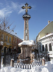
Baroque Merchant Cross
This Orthodox memorial of the Merchant Association was erected on the main square of the city in 1763, after the fortunate event of the plague epidemic not affecting the city. It is believed that under the cross ornamented with icons painted on tin plate a plague-victim’s head is buried.
Churches
The people who escaped here from different parts of the Balkan built their own churches separately, altogether eight, out of which seven still exist and the name of four of them show where their builders came from.
Omadused, tunnused
Tüüp:
Väikelinna, aleviku
Asukoht:
Euroopa (Mandril) > Ungari (Riik) > Budapest ja selle ümbrus (Turismi ala) > Pest megye (county) (Maakond, komitaat) > Danube Bend (Dunakanyar) (Geograafiline piirkond)
GPS koordinaadid: Laiuskraad 47°40'24", Pikkuskraad 19°4'21" (N47 40.4 - E19 4.35)
Szentendre - Fotoalbumi, fotod, pildigaleriid (597 fotot / 11 galeriid)


Szentendre - Panoraampilte (1 fotot)

Samuti võite olla huvitatud (Seotud lehed):
Reisijuhi sihtkohad:
Szentendre (597 fotot + 1 panoraampilte)
Danube Bend (Dunakanyar) (1 769 fotot + 6 panoraampilte)
Pest megye (county) (15 122 fotot + 50 panoraampilte)
Budapest ja selle ümbrus (15 989 fotot + 52 panoraampilte)
Ungari (27 287 fotot + 163 panoraampilte)
ja lisaks:
(jooksul siin: Pest megye ja Danube Bend)
Pilis Mountains (Pilis hegység) (335 fotot)
Buda Hills (Budai-hegység) (8 632 fotot + 21 panoraampilte)
Gödöllő Hills (Gödöllői-dombság) (4 203 fotot + 21 panoraampilte)
Visegrád Mountains (Visegrádi-hegység) (116 fotot + 1 panoraampilte)
Cegléd (125 fotot + 2 panoraampilte)
Ráckeve (92 fotot)
Dunakeszi (259 fotot)
Göd (23 fotot)
Nagykőrös (250 fotot + 2 panoraampilte)
Nagymaros (31 fotot)
Pilisvörösvár (88 fotot)
Vác (232 fotot + 2 panoraampilte)
Visegrád (220 fotot + 1 panoraampilte)
Esztergom (110 fotot + 1 panoraampilte)
Dunakeszi (259 fotot)
Göd (23 fotot)
Nagymaros (31 fotot)
Vác (232 fotot + 2 panoraampilte)
Visegrád (220 fotot + 1 panoraampilte)
Csővár (105 fotot)
Kóspallag (53 fotot)
Márianosztra (37 fotot)
Nagybörzsöny (4 fotot)
Pilisszentkereszt (122 fotot)
Nógrád (181 fotot)
Zsámbék
Iga panoraamfoto siin:
Szentendre (1 fotot)
Danube Bend (Dunakanyar) (6 fotot)
Pest megye (county) (50 fotot)
Budapest ja selle ümbrus (52 fotot)
Ungari (163 fotot)
Euroopa (165 fotot)
Iga tavaline foto siin:
Szentendre (597 fotot / 11 galeriid)
Danube Bend (Dunakanyar) (1 769 fotot / 31 galeriid)
Pest megye (county) (15 122 fotot / 221 galeriid)
Budapest ja selle ümbrus (15 989 fotot / 234 galeriid)
Ungari (27 287 fotot / 462 galeriid)
Euroopa (30 494 fotot / 523 galeriid)
https://www.panadea.com/et/guidebook/szentendre

Lisa Lemmikutesse Lisa Järjehoidjatesse
Jagage oma sõpradega!
jne


Meie reisijuht sisaldab:
Palju pilte ja panoraamfotosid, kus on palju teavet ja huvitavaid fakte.
- 214 reisisihtkoht
- 165 panoraampilte
- 30 494 teised fotod
Suur fotokogu: suurepärane kvaliteet, kõrge resolutsiooniga ja looduslikud värvid
Firmast - Õigusteave -
Kõik õigused kaitstud
- ©2010-2022
Neuronit Creative Studio - Mogyoród / Budapest / Ungari